Technical Update
Ecology Overview
The Site’s ecological status has been established through field survey and desk-based assessments carried out between 2021 and 2025. The Site has no statutory designations, though the Upper Nene Valley Gravel Pits Special Protection Area, Ramsar site and Site of Special Scientific Interest (SSSI) is 2.9km north and Salcey Forest SSSI is 4.4km southwest. One non-statutory designation (Potential Wildlife Site 235) lies within the Site, with a further 18 within 2km.
Habitats present mainly consist of grazed modified grassland and arable fields, bounded by hedgerows, trees, and ditches. Wootton Brook forms a key green corridor through the centre of the Site. Other habitats present include tall forb vegetation, scrub, ponds, and farm buildings.
Surveys have confirmed the presence of breeding and wintering birds, bats, otter, water vole, amphibians and reptiles. The design retains higher-value habitats and incorporates suitable mitigation where impacts to habitat and species may occur. The development also offers opportunities for biodiversity enhancement, including species-rich grassland, wetland and pond creation, hedgerow enhancements, and native tree and shrub planting.
Landscape and Visual Overview
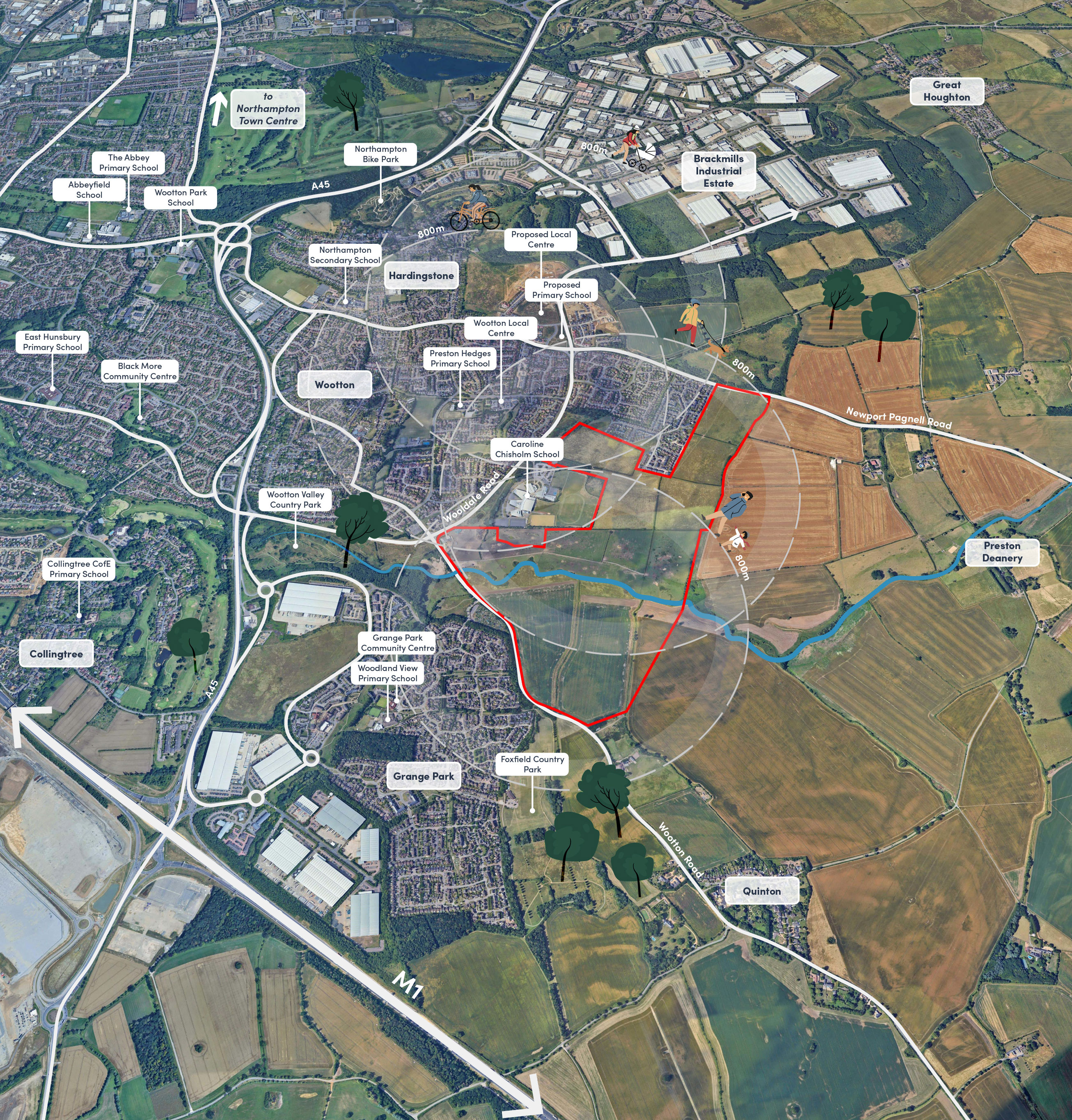
The Wootton Valley Site lies within a gently rolling agricultural landscape on the eastern edge of Northampton. It is defined by open fields, hedgerows, scattered trees and the Wootton Brook running through its centre. While the Site itself has no national or local landscape designations, nearby features such as Wootton Conservation Area and the historic parklands at Courteenhall and Preston Deanery contribute to the wider character of the area.
The design has been shaped by these existing landscape features. The landform, hedgerows, mature trees and the brook corridor have guided where development is proposed and where green spaces are prioritised, helping new homes sit comfortably within their surroundings.
A major opportunity is the enhancement of the Wootton Brook corridor. This area will be transformed into a biodiverse green space through the creation of meadows, wetlands, woodland planting and improved walking and cycling routes. Hedgerows and trees will be retained wherever possible and strengthened with new planting to support wildlife and soften views. The eastern edge of the Site will include a new green corridor to create a gentle transition between Wootton and the countryside.
Overall, the landscape strategy aims to provide a high-quality green setting, enhance biodiversity and create accessible open spaces for both new and existing residents.
Drainage
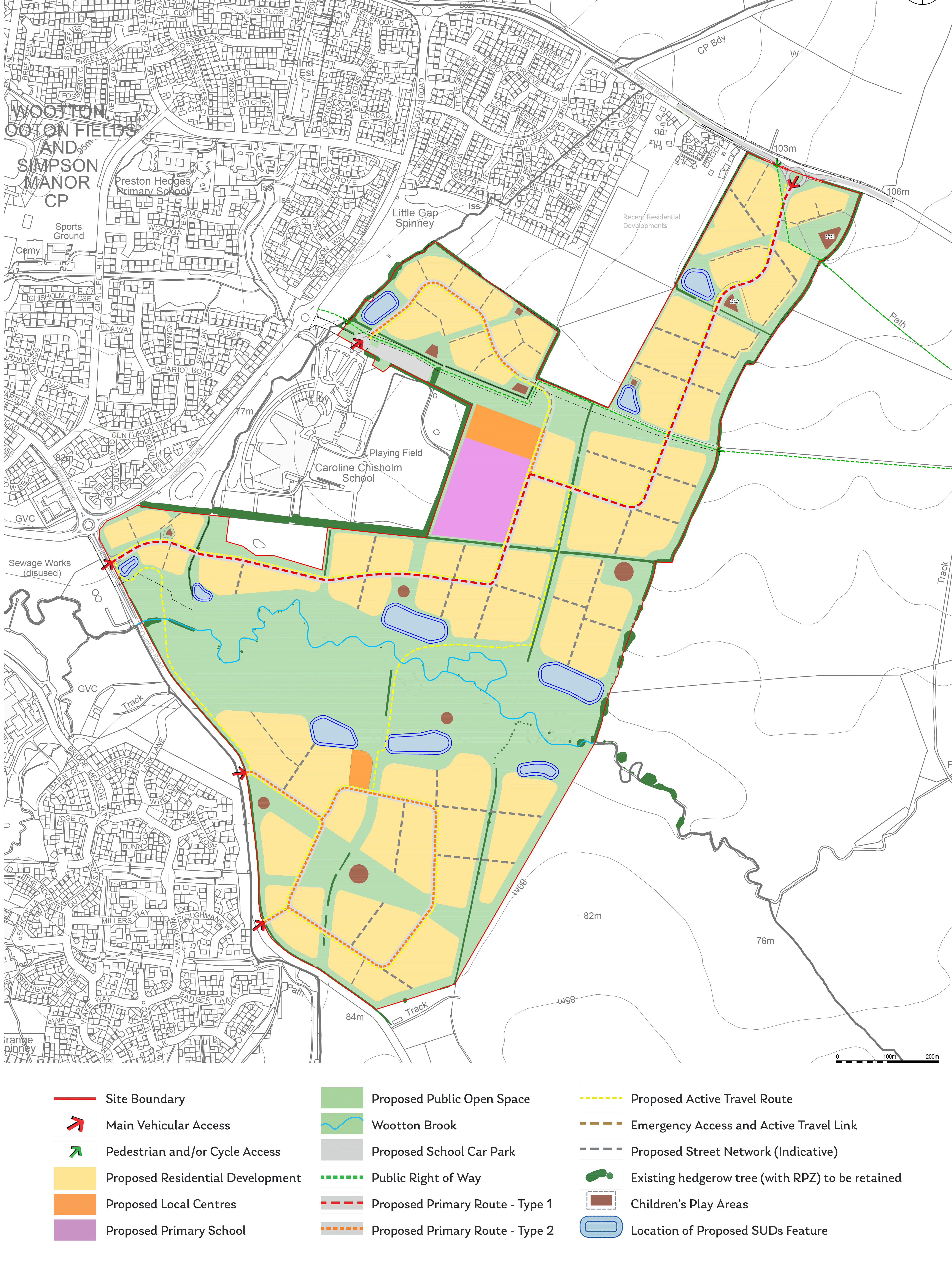
The surface water drainage network proposes a SuDS based blue-green approach. Above ground surface water detention basins and swales are to be placed strategically within landscaped areas that bisect the proposed development.
The strategy has been designed to mimic the pre-development scenario, a detailed review of the topography identified flow routes and existing watercourse catchments. The proposed strategy maintains the current catchments and utilises the existing watercourses as outfalls for various development parcels.
Run-off from all parcels will be attenuated to a greenfield discharge rate, so that there is no impact downstream. Infiltration is not proposed for the development due to the geology and poor infiltration rates. Development parcels shall be designed with a range of source control features, to ensure interception design has been fulfilled, in accordance with the latest SuDS guidance.
Transport and Highways
Vehicular Access
Given the extensive adopted highway frontages to the site, there are numerous opportunities to provide a range of vehicular access points to the site. The site has an extensive frontage to both the B526 Newport Pagnell Road and Quinton Road/Wootton Road. There is also the potential for an additional access using the existing, albeit upgraded, vehicular access to the Caroline Chisholm School to the west of the site. At this stage of the planning process that there will be five formal adopted vehicular access points to the site, namely:
- Roundabout on Newport Pagnell Road.
- Extension off existing Caroline Chisholm School roundabout.
- Three priority junction access points from Wootton Road.
The geometric criteria for undertaking each access have been referenced from Manual For Streets and also from guidance set out in the Design Manual for Roads and Bridges (DMRB). The DMRB forms part of the Manual of Contract Documents for Highway works. The junction alignment parameters are taken from the DMRB document CD123 Geometric Design of at Grade Priority and Signal Controlled Junctions, forming part of the road layout section of the Design Manual For Roads and Bridges. The standards apply to both single and dual carriageway roads in urban and rural areas. The standards define a sequence of parameters related to junction designs and amongst other variables incorporates sight distance, horizontal alignment, and lane widths. More locally Northamptonshire have a residential design guide in circulation, the most recent version being from November 2003. This of course pre-dates, and will in general be superseded by, Manual for Streets.
The main spine road within the site will be 6.5 metres wide (sufficient to accommodate a formal bus route) and will have a 5 metre wide segregated footway and cycleway on one side and a 2 metre wide footway on the other, both separated by a verge of 2.5m wide tree lined from the road. The land required for the access points are all within the site boundary.
As such, the site can be satisfactorily accessed via the above locations.
Sustainable Access
General cycle and pedestrian access will be taken via the proposed new accesses although there are further opportunities to enhance and make better use of existing public rights of way which link the site with the surrounding as detailed in the wider Vision Document. Additional pedestrian and cycle links will be included on Newport Pagnell Road, Quinton Road and across Wooldale Road to tie in with the existing and proposed pedestrian infrastructure. Improvements will be required in the form of new sections of footway and/or cycleway as well as a more formal controlled crossing of Wooldale Road to assist the connectivity of the site with existing built development within the existing Wootton and Wootton Fields area. This could include a crossing point to connect to the existing public rights of way LF1 and LF4. Within the site, formal vehicular connections will be provided with each main portion of the site being served by the 6.5m wide access road with a footway/cycleway on one side and a footway on the other, as detailed above.
The two main portions of the site will be connected by a number of formal pedestrian and cycle links to allow a comprehensive network of routes across the site running between Newport Pagnell Road, Wooldale Road and Quinton Road. All of the land required for all of the vehicular access arrangements is controlled by Gand Barratt Redrow or on currently adopted highway.
Initial discussions have taken place with officers at West Northamptonshire Council and the principle of the location and design of the main access points has not been objected to. These discussions will continue as the allocation process progresses.
Traffic Impact
The impact of the proposals will be considered in detail within the forthcoming planning application. A formal Transport Assessment will consider the impact of the proposals and as part of this exercise the updated Northampton Strategic Traffic Model (NSTM) will be used. This will provide the information required to assess the impact at each individual junction on the surrounding road network. Where required, formal physical mitigation will be provided to ensure that the impact of the proposals is not severe in the context of the NPPF.